
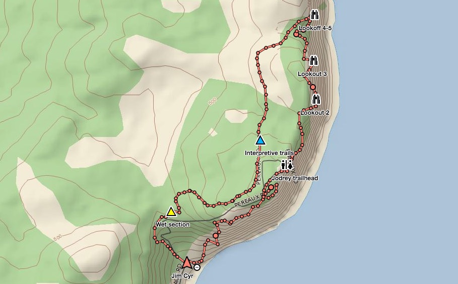
 Jodrey Trail
5.6 km (3.5 mi.) | Moderately Challenging Trail
The trail skirts 183 m (600 ft.) sea cliffs with numerous viewing stations overlooking the Minas Basin. The trail gradually climbs to 190 m, winding through a sugar maple, yellow birch and beech forest
Jodrey Trail
5.6 km (3.5 mi.) | Moderately Challenging Trail
The trail skirts 183 m (600 ft.) sea cliffs with numerous viewing stations overlooking the Minas Basin. The trail gradually climbs to 190 m, winding through a sugar maple, yellow birch and beech forest
Look-Off Trail 900 m (0.6 mi.)| Basic trail The trail climbs through sugar maple and yellow birch forest reaches 160 m, offering views of the Minas Basin and Five Islands Provincial Park, 24 km (15 mi.) across the bay. The Woodland Trail 2.5 km (1.3 mi.) | Basic trail A pleasant walk through a mixed forest of sugar maple, yellow birch, white spruce and balsam fir.
Borden Brook Trail 3.5 km (2.2 mi.) | Moderately Challenging Trail Located about halfway between the day-use area and the park office. The trail climbs to a height of 185 m crossing Borden Brook, with a short walk to a waterfall.
More about the park: http://parks.novascotia.ca/content/blomidon-hiking-trails
Trip Summary: Blomidon Provincial Park
Trip Stats
11.9km
Distance
7.4mi
Distance
4h 03m
Total time
2.9km/h
Avg speed (incl. stops)
2.9km/h
Moving speed
550m
Elevation gain
546m
Elevation loss
215m
Highest point
Elevation Profile
Terrain & Pace Summary
Hilly / Technical
This route packs 550 m of climbing over 11.9 km (46 m/km) — expect frequent ups and downs and sections that demand attention.
Technical / Slow-going
Tight trails, obstacles, or frequent stops kept speeds low — come prepared.
Points of Interest near Start / End
⚠️ The businesses below were identified from public mapping data at the time of generation.
Always verify hours and ATV-friendliness before you ride.
Accommodation
Airbnb near trailhead
Search Airbnb for rural properties that welcome trailers.
View on Maps / WebTrail Access & Pass Information
⚠️ Trail pass and gate information changes seasonally.
The notes below are based on publicly available information at time of generation — verify before you go.
- Check your provincial / state OHV registration requirements before riding.
- Verify gate and seasonal-closure status with a local ATV club or land manager.
- Some trail networks require a separate trail pass — confirm with the local OHV association.
Recent Trail Notes
Recent trail-related items found during a five-year news and organization scan. Conditions and access can change quickly, so verify details with the park, trail manager, or local association before heading out.
Blomidon Provincial Park
- 2021-08-12 – HIKING NOVA SCOTIA: Blomidon's Jodrey, Woodland trails are worth the walk for an epic adventure – PNI Atlantic News (PNI Atlantic News)