
Last updated: July 26, 2026. Cape Chignecto is a difficult coastal backcountry route. Verify current park advisories, reservations, tides, water treatment and backcountry rules before hiking.
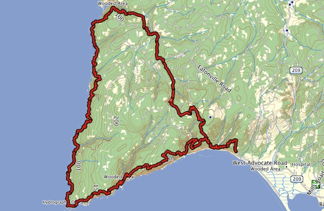
Cape Chignecto Provincial ParkCape Chignecto is a 4,200-hectare natural environment park on a dramatic coastal peninsula. The park features 29 kilometres (18 miles) of pristine coastline, some of Nova Scotia’s most significant geological features, deep valleys, sheltered coves, rare plants, remnant old growth forest, scenic views, and a rich cultural heritage. We offer wilderness camping in secluded coves and ravines, while a spectacular coastal hiking trail leads visitors along high cliffs and deep valleys. Because Cape Chignecto is a wilderness hiking park, there are no drive-up camping sites.The following track file is the common loop backcountry hikers attempt when visiting the park. This loop can be done typically in 2-3 days. For day trips, there are a number of options available. Click HERE to view the trails at the park.
Trip Summary: Cape Chignecto Provincial Park
Trip Stats
49.3km
Distance
30.6mi
Distance
9h 17m
Total time
5.3km/h
Avg speed (incl. stops)
5.3km/h
Moving speed
3018m
Elevation gain
3016m
Elevation loss
277m
Highest point
Elevation Profile
Terrain & Pace Summary
Hilly / Technical
This route packs 3018 m of climbing over 49.3 km (61 m/km) — expect frequent ups and downs and sections that demand attention.
Technical / Slow-going
Tight trails, obstacles, or frequent stops kept speeds low — come prepared.
Points of Interest near Start / End
⚠️ The businesses below were identified from public mapping data at the time of generation.
Always verify hours and ATV-friendliness before you ride.
Accommodation
Airbnb near trailhead
Search Airbnb for rural properties that welcome trailers.
View on Maps / WebTrail Access & Pass Information
⚠️ Trail pass and gate information changes seasonally.
The notes below are based on publicly available information at time of generation — verify before you go.
- Check your provincial / state OHV registration requirements before riding.
- Verify gate and seasonal-closure status with a local ATV club or land manager.
- Some trail networks require a separate trail pass — confirm with the local OHV association.
Recent Trail Notes
Recent trail-related items found during a five-year news and organization scan. Conditions and access can change quickly, so verify details with the park, trail manager, or local association before heading out.
Cape Chignecto Provincial Park
- 2026-03-27 – Cape Chignecto Provincial Park: Explore Nova Scotia’s Wild Coastal Escape – To Do Canada (To Do Canada)
- 2021-12-21 – Two new FKT’s set on Nova Scotia’s Cape Chignecto Provincial Park Loop – Canadian Running Magazine (Canadian Running Magazine)
Current References
- Nova Scotia Parks: Cape Chignecto
- Nova Scotia Parks: Cape Chignecto hiking trails
- Nova Scotia Parks reservations
- Canadian Tide and Current Tables