
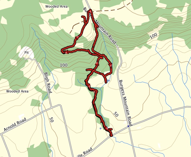
Last updated: July 26, 2026. Woodville Community Centre currently says the Woodville Hiking Trail System is closed because the property was sold and the land-use agreement is no longer in effect. Do not rely on this legacy route without confirming access.

This page remains useful as a legacy record of Jim’s earlier Woodville hike and GPX route. Treat it as historical trip information, not a current recommendation to hike the trail.
Before You Go
- Check the Woodville Community Centre page for the latest access notice.
- Respect private land and posted closures.
- Choose another Annapolis Valley hike if current access is not confirmed.
Related Avoiding Chores Links
- Hike To Cape Split
- Blomidon Provincial Park Hiking Trails
- Avondale Peninsula Westbrook Trail
- Nova Scotia Hiking Trail Guide
- Garmin Maps: Paid vs Free
- Garmin inReach Messenger How-To Tutorials
- ZOLEO Satellite Communicator Overview
Current References
Trip Summary: Woodville Hiking Trails
Trip Stats
8.0km
Distance
5.0mi
Distance
2h 43m
Total time
2.9km/h
Avg speed (incl. stops)
2.9km/h
Moving speed
324m
Elevation gain
309m
Elevation loss
206m
Highest point
Elevation Profile
Terrain & Pace Summary
Hilly / Technical
This route packs 324 m of climbing over 8.0 km (41 m/km) — expect frequent ups and downs and sections that demand attention.
Technical / Slow-going
Tight trails, obstacles, or frequent stops kept speeds low — come prepared.
Points of Interest near Start / End
⚠️ The businesses below were identified from public mapping data at the time of generation.
Always verify hours and ATV-friendliness before you ride.
Accommodation
Airbnb near trailhead
Search Airbnb for rural properties that welcome trailers.
View on Maps / WebTrail Access & Pass Information
⚠️ Trail pass and gate information changes seasonally.
The notes below are based on publicly available information at time of generation — verify before you go.
- Check your provincial / state OHV registration requirements before riding.
- Verify gate and seasonal-closure status with a local ATV club or land manager.
- Some trail networks require a separate trail pass — confirm with the local OHV association.